GeoRank
Stop guessing where to live; GeoRank pinpoints your perfect place by comparing sunshine, cost, taxes, and visas.
AI tool Details
About GeoRank
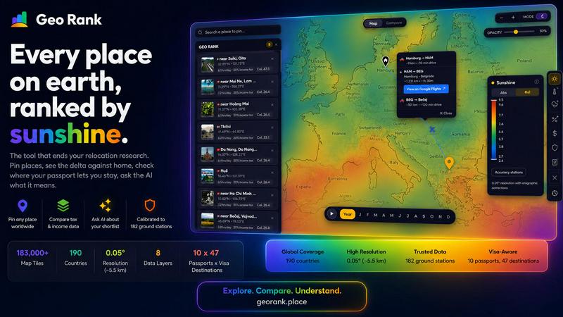
GeoRank is a revolutionary, free, no-signup interactive map tool designed to end the chaos of relocation research. It replaces the dozen open tabs of weather sites, cost-of-living calculators, visa guides, and expat forums with a single, integrated decision platform. Built for digital nomads, remote workers, expats, and anyone contemplating a move abroad, GeoRank layers nine critical data sets over a high-resolution global grid. By integrating calibrated sunshine and temperature data from 182 ground stations, tax rates from authoritative sources like the OECD and PwC, per-passport visa and residency routes across 47 destinations, cost-of-living data from 478 cities, and community-sourced sentiment, it transforms overwhelming research into a clear path forward. The core value proposition is empowerment through clarity. You can explore the world, pin your candidate locations, and instantly compare them against your current home, seeing every metric as a meaningful delta. The tool culminates in a unique AI assistant that reasons only over your personal shortlist, providing grounded, cited answers to complex questions like "Which of my places has the best winter?" GeoRank is not just for browsing data; it is built for the actual, high-stakes decision of choosing where to live next.
Features
9 Integrated Data Layers
GeoRank stacks nine live, toggleable data layers onto a single, interactive map. These include calibrated sunshine, temperature, rainfall, outdoor hours, tax rates, visa and residency routes, cost of living, geopolitical risk, and Nomad Pulse community sentiment. You can toggle any layer on or off to visualize the world through the lens of your specific priorities, blending official statistics with real-world community feedback for a holistic view.
Pin, Compare, and See the Delta
The core decision-making engine allows you to pin up to 20 locations on the map, which are saved across your sessions. By switching to Compare mode and setting your current home as a baseline, every metric for your pinned places is displayed as a clear delta. You instantly see how much warmer, cheaper, safer, or differently taxed a potential new home is compared to where you live now, turning absolute numbers into personal, actionable insights.
AI Assistant for Your Shortlist
GeoRank features a powerful AI chat that operates exclusively on your pinned locations, not a generic knowledge base. You can ask complex, comparative questions like "Which of my 5 places has the best winter?" or "Score my shortlist for low tax and sunshine." The AI reasons across all your specific data points in one response, providing cited, grounded answers that help you weigh trade-offs and make a confident final decision.
Calibrated, Ground-Truth Data
Unlike tools that rely on raw satellite or reanalysis data, GeoRank's climate layers are bias-corrected against 182 ground reference stations. This process, using SARAH-3 satellite data, ERA5 reanalysis, and orographic terrain corrections, ensures exceptional accuracy. This means the sunshine hours for a cloudy coastal city or a high-altitude town are realistic and dependable, giving you a true picture of local conditions, not just a satellite's estimate.
Use Cases
Digital Nomad Shortlisting
A digital nomad with a UK passport, wanting to maximize sunshine while minimizing taxes, can use GeoRank to shortlist cities like Paphos and Tbilisi. They can pin both, set their home base, and instantly see the delta in cost, sunshine hours, and visa-free stay duration. The AI can then answer a specific question like, "Which of these two meets my 2,800 sunshine hour requirement and offers the best tax structure for a freelancer?" providing a clear, data-backed recommendation.
Family Relocation Assessment
A family considering a move from London to Valencia or Lisbon can use GeoRank to evaluate trade-offs beyond just climate. They can compare cost of living deltas for a family of four, assess geopolitical risk scores, and check visa pathways. The AI can synthesize this data to answer a complex query like, "Which location has better outdoor hours for kids in the winter and a lower geopolitical risk score?" helping the family prioritize safety and lifestyle for their children.
Retirement Planning
A couple planning their retirement abroad can use GeoRank to identify locations that offer a specific combination of low tax, low cost of living, and a stable political environment. They can pin several candidate countries in Southeast Asia and Central America, using the compare mode to see the delta against their current home in the US. The AI can then help them refine their list by asking, "Which of my pinned places has the lowest combined income and property tax rate for a retiree?"
Career Break Exploration
An individual planning a six-month career break can use GeoRank to find a temporary base that offers a vibrant community and good value. They can filter by the Nomad Pulse sentiment layer to see where enthusiasm is building among other remote workers. By comparing cost of living and visa duration across several pinned cities in Eastern Europe or South America, they can identify a location that fits their budget and offers a welcoming, active community for their time abroad.
Frequently Asked Questions
Is GeoRank really free and do I need to sign up?
Yes, GeoRank is completely free to use and requires no signup or account creation. You can access the interactive map, toggle all nine data layers, pin locations, and use the compare mode immediately. Your pinned locations are saved locally in your browser, allowing you to return to your research without needing an account.
How accurate is the climate data on GeoRank?
GeoRank's climate data is highly accurate because it is calibrated against ground truth. While raw satellite data can overestimate sunshine in cloudy regions, GeoRank merges SARAH-3 satellite observations with ERA5 reanalysis data and bias-corrects the results against 182 ground reference stations. This process, which includes orographic terrain corrections, gives a typical accuracy of ±8% for most locations, making it a reliable tool for decision-making.
What does the AI assistant know, and how does it work?
The AI assistant on GeoRank is unique because it only knows about the locations you have pinned on your map. It does not access a general knowledge base. When you ask a question like "Which of my places is best for winter?" it analyzes the specific climate, tax, cost, and visa data for each of your pinned places and reasons across them to give you a comparative, cited answer. This ensures the answers are directly relevant to your personal shortlist.
What data sources power the different map layers?
GeoRank uses a variety of authoritative sources. Sunshine, temperature, and rainfall data come from SARAH-3, ERA5, and CHELSA. Tax rates are sourced from the OECD, PwC, and KPMG databases. Visa information covers 47 destinations for 10 different passports. Cost of living data is aggregated from 478 cities worldwide. The Nomad Pulse layer is a community-sourced sentiment indicator based on social media processing.
Similar to GeoRank

screenRIG
Signage and kiosk infrastructure for AI agents. Your agent publishes images, video, streams, web pages and apps to screens via one plugin.screenRIG is

AUTOMATER.ai
A tray helper for every AI coding tool: sessions, alerts and usage in one place

Orlyn
Privacy-first web analytics that connects traffic directly to real revenue.
GetYouTubeTranscript
Free YouTube transcripts on the web, a Chrome extension, and an API + MCP server so AI assistants can read YouTube.